
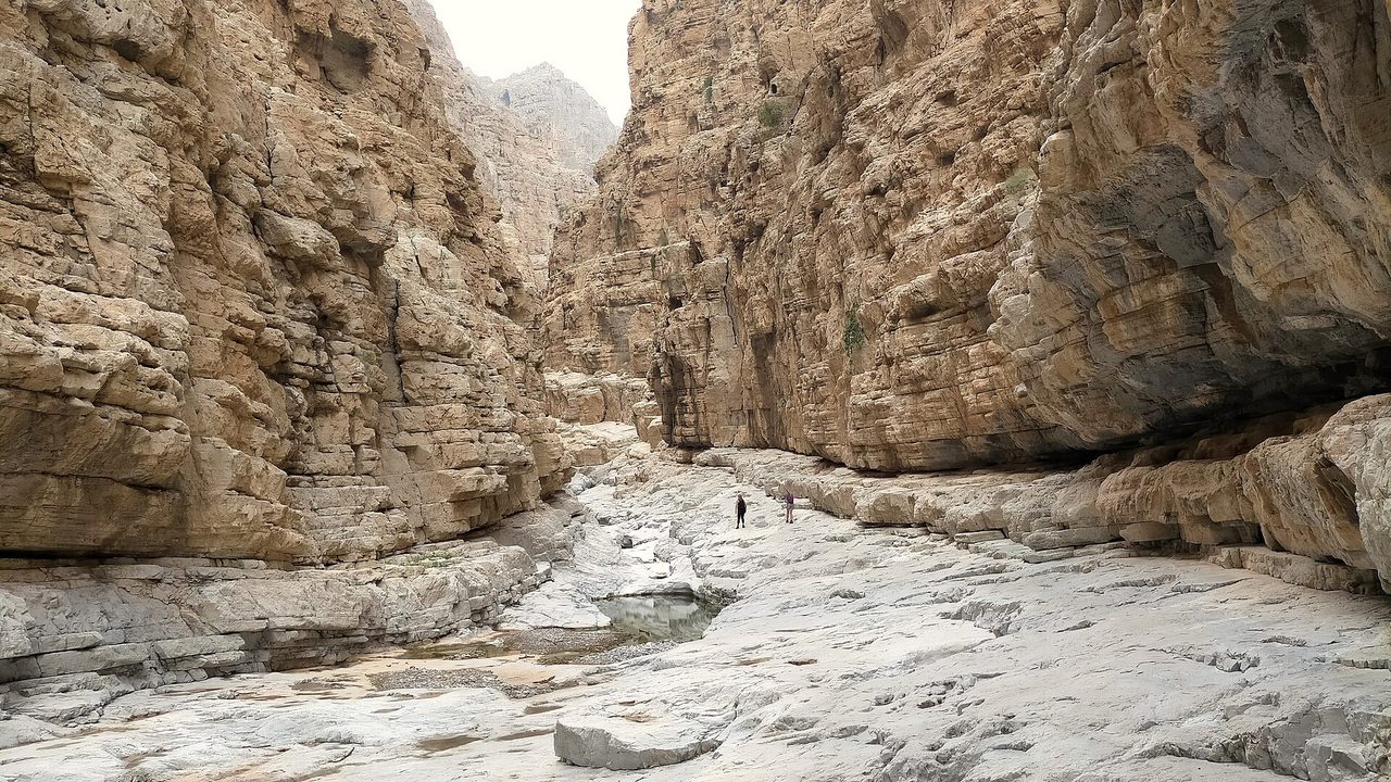
This is an unofficial walk from Wadi Naqab into the narrow Wadi Koub (also written Wadi Kub) and up to the abandoned village of Al Sanat in Ras Al Khaimah. It is not the drive-in camping Wadi Kub near Masafi. Sources give 7.7 to 14km and about 6 hours. It is exposed, thinly marked and has little or no mobile signal, so it is for experienced walkers in the cooler months or those with a licensed guide.
Why it is graded Difficult
There is no official grade. Visit Ras Al Khaimah calls the Red Wall hike in Wadi Naqab moderately challenging, and a Wikiloc track page says Moderate. Gulf News says it is for seasoned hikers, and The Road Reel recommends a guide for beginners. We rate it Difficult because of the exposed ledges, scree, thin markings, lack of signal and repeated rescues in Wadi Naqab.
We use one scale across all our routes: how we grade.
The route
This guide covers the Wadi Kub (also written Koub or Koob) canyon and pools that you reach on foot from Wadi Naqab. It is not the drive-in camping Wadi Kub near Masafi, off the Gragrah to Ghub road. Walkers describe one route from the Wadi Naqab trailhead. You cross about 2km of boulders in the wadi bed, take a signed path along a ledge on the left to bypass the dead end at the Red Wall, then enter the narrow Wadi Koub with its seasonal pools.
In Wadi Koub there is a short ledge with a metal rope, a spot with a UAE flag, polished rock and a boulder section with a narrow gap to crawl through. Al Sanat is the hardest part: a staircase with black ropes, then about 45 minutes up loose rock and scree to the abandoned village. Markings run out after the staircase.
You return by a ridge on the far side of the village, with loose rock, then rejoin the wadi and retrace your steps. Visit Ras Al Khaimah says most Wadi Naqab walks are there-and-back with no shortcuts to the vehicle. Start by 8am to finish in daylight.
- Distance
- Not confirmed. Komoot gives about 8.5km and Wikiloc 7.7km. The Road Reel says 14km but its own sections add to about 8.5km.
- Climb
- Not confirmed. The Road Reel gives 515m but its own high and low points do not add up. Other pages give 257m to 846m for nearby routes.
- Time
- About 6 hours in most sources; The Road Reel says 5 to 6 hours of walking.
Trailhead
- Start
- The closest drivable parking in Wadi Naqab, at a sign on the rocks. There is no official trailhead. Set your map to Wadi Naqab, not to the Masafi camping Wadi Kub, which is a different place (MissionsOffroad).
- Coordinates
- 25.72122, 56.12466
The pin comes from two walkers' track pages that agree to about 10 metres. No government source gives a coordinate, and the road end may change. - Parking
- Informal parking at the end of the dirt road. No official car park or charge is described. Where you can park depends on the road, which has been reported as damaged. Check before you go.
- Vehicle
- Not confirmed. Visit Ras Al Khaimah advises a 4x4 for the last few kilometres. Some walkers say a sedan can now reach the start.
- Getting there
- Visit Ras Al Khaimah says about 2 hours from Dubai and 40 minutes from Ras Al Khaimah city. Turn right at Al Salihia.
When to go
- Best months
- The Road Reel recommends December to February, and mid-October to mid-March for early starts. Visit Ras Al Khaimah says October to April. Do not walk it in summer.
- Start time
- Start at first light, by 8am at the latest, so you are off the route before dark.
- Shade
- Not confirmed. No source describes shade on the route.
- Water
- None you can rely on. Pools may be dry, and the year-round pool is described as not clean. Carry at least 4 litres each.
- Mobile signal
- Poor to none in the wadi. Some signal at Al Sanat. Download an offline map and track.
Fees, permits, hours and closures
- Fees
- No fee found. Visit Ras Al Khaimah says no permit is needed. Last checked October 2026.
- Permits
- Visit Ras Al Khaimah says no permit is needed, but groups of 10 or more should contact the tourism authority in advance. The National reported in 2023 that hiking rules for Fujairah and Ras Al Khaimah include trail registration and a qualified leader for organised groups. Check whether they apply to you. Last checked October 2026.
- Hours
- No hours are published. The wadi is open access. Last checked October 2026.
- Closures
- No closure notice was found, but no official body publishes a status for this route. The road to the trailhead has been reported damaged by water. Check the road and the forecast on the day. Last checked October 2026.
Checked on 8 October 2026. Rules and closures change, above all after rain: check the source pages below on the day.
Safety
- Do not go if rain is forecast anywhere in the mountains, or if it has rained recently. Flash floods are described as deadly in Wadi Naqab, and the canyon has no easy exit.
- Police have rescued hikers in Wadi Naqab many times since 2020, including a man who died in February 2023. Reports do not say which trail each was on.
- Expect narrow ledges, a rope-assisted ledge, a gap to crawl through and a steep climb on loose scree to Al Sanat. You need a good head for heights.
- Markings run out after the staircase and some walkers have got lost. Load an offline track, and go with a licensed guide if you have not walked it before.
- Do not walk it from May to September. Police rescued an exhausted man in April 2020 and four tourists in September 2020 and urged people to avoid mountain hikes in high temperatures.
- Do not hike alone. There is no signal in the wadi, so tell someone your route and return time.
- Finish before dark. A rescue in January 2022 was four women lost after dark. Turn back if you are behind schedule.
- Carry at least 4 litres of water each. Do not rely on the pools.
What to carry
- At least 4 litres each
- Rehydration drink and food
- Offline map and GPS track
- Sturdy boots with good grip
- Sun hat, sunglasses and sunscreen
- Head torch
- First aid kit
- Charged phone and power bank
Tell someone your route and when you expect to be back. Turn around if the weather, the heat or the time is against you. We describe this route from published sources; we have not surveyed it, and nothing here is a statement that it is safe for you on the day.
Police 999 · Ambulance 998 · Civil Defence 997
What we could not confirm
- Which place you are heading for. This page covers the Wadi Kub canyon reached on foot from Wadi Naqab, not the camping Wadi Kub near Masafi. No source describes a walk linking the two.
- The distance and the climb. Sources disagree, and the figures here are rough.
- Where the road ends and where you can park. The road has been reported damaged, and sources disagree on whether a sedan can reach the start.
- Whether trail registration or a qualified leader is required where you start. Ask Visit Ras Al Khaimah.
- Whether the markings on the route are current. They are informal and may have changed.
Sources
- The Road Reel: How to hike from Wadi Naqab to Wadi Koob pools and Al Sanat Village (distance, sections, coordinates, hazards, guide advice; published 9 February 2021, updated 16 February 2026)
- Wikiloc (via loc.wiki): Wadi Naqab - Wadi Koub - Al Sanat Village (7.7km, Moderate, coordinates, warnings, comments)
- Visit Ras Al Khaimah: Wadi Naqab hiking guide (Red Wall and Sheri/Baqal routes, red markers, 4x4, no permit, groups of 10 or more; published 5 March 2026, modified 13 March 2026)
- Komoot: Wadi Naqab Canyon highlight (FAQ gives about 8.5km and 6+ hours for the Wadi Naqab to Wadi Kub route; coordinates 25.723071, 56.141505)
- MissionsOffroad: The Secrets of Wadi Naqab (published 8 April 2020, updated 10 June 2020: access, flash floods, getting lost, Wadi Koub coordinates)
- MissionsOffroad: Wadi Kub (the drive-in Wadi Kub off the Gragrah to Ghub road, and the note that another Wadi Kub is reached from Wadi Naqab; published 27 June 2021, updated 1 June 2024)
- Wikipedia: Wadi Naqab (location, dam, routes to Sheri and Wadi Kub, rescues)
- Wikipedia: Wadi Kub (a Fujairah and Ras Al Khaimah wadi draining to Wadi Mu'taridah near Saram; mouth 25.6545, 55.9995; no hiking mentioned)
- Gulf News: 7 UAE hiking trails for expert trekkers (Wadi Naqab loop to Al Sanat about 6 hours, seasoned hikers; updated 29 October 2025)
- ECC Adventures: Wadi Koob and Wadi Naqab (tour operator, 10km out-and-back, 257m gain, guide, flash-flood and rescue warning)
- Wikiloc (via loc.wiki): Heli Hike (Reverse) Wadi Kub, Wadi Naqab end of road (canyon, slippery rock, flash-flood warning, markings)
- idoitcauseican: Wadi Naqab hike (20 February 2019; older trailhead coordinates, Sheri route; no mention of Koub)
- Property Finder: Wadi Naqab trails (published 11 April 2025, modified 13 May 2026; Red Wall 7km and 846m, a different figure set)
- WOW-RAK: Best wadis in Ras Al Khaimah (rescues called out most in the upper reaches; no guide required for individuals; updated 29 September 2026)
- Al Bayan: rescue of an exhausted man in Wadi Naqab (20 April 2020, Arabic)
- Dubai Eye 103.8: RAK Police rescue 4 stranded tourists in Wadi Naqab (6 September 2020)
- The National: 'People are risking their lives': safety warning after more stranded hikers rescued (6 September 2020)
- Gulf News: RAK Police rescue nine people stranded in Wadi Naqab (15 December 2020)
- Emarat Al Youm: nine people stuck in Wadi Naqab for a full day (16 December 2020, Arabic)
- Gulf Today: RAK team rescues 8 people from mountains (6 February 2021)
- The National: hiker flown to hospital after breaking leg, Wadi Naqab (22 December 2021)
- The National: four women hikers lost in Wadi Naqab brought to safety (5 January 2022)
- The National: Austrian man dies on hiking trip, Wadi Naqab trail (14 February 2023)
- Khaleej Times: young European hiker found dead after falling from mountain in Ras Al Khaimah (February 2023; wadi not named)
- Gulf Today: RAK Police rescue three tourists in Wadi Naqab (22 May 2023)
- The National: UAE hiking season gets under way with new rules (24 October 2023, updated 4 March 2024)
- The National: Fujairah to fine tourism companies Dh50,000 (3 March 2023)
- The National: the RAK mountain tribe that guides lost trekkers home (16 January 2019; the Wadi Kub foothill town about 40km south of Ras Al Khaimah city, 'kub' means cup)
- Ajman government: emergency numbers
- Wikimedia Commons: File:Wadi Naqab - 13.jpg, by IbrahimKumar, CC0 (photo)
Last checked 8 October 2026