
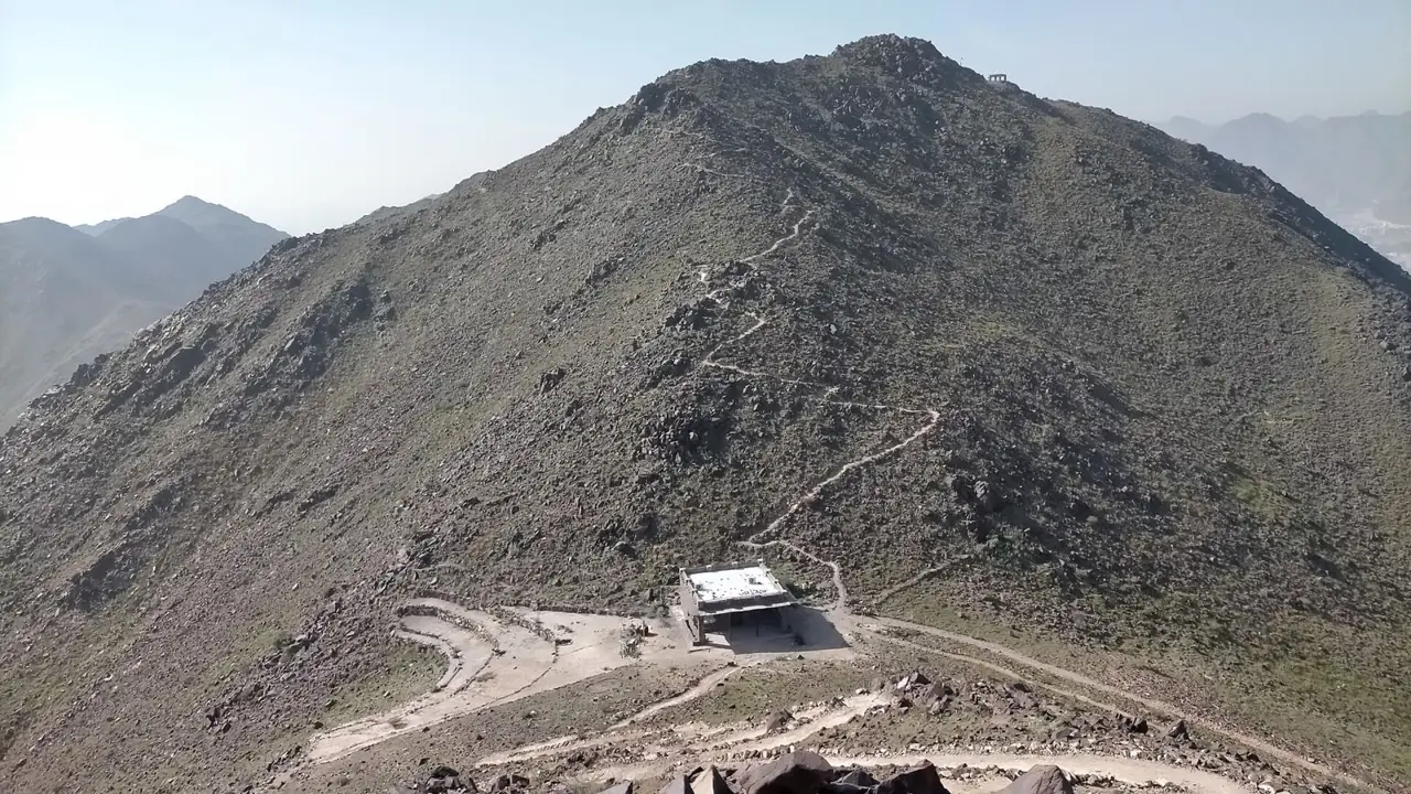
Al Rabi Tower Trail climbs the mountain above Khor Fakkan from a restored 1915 watchtower to a flag on the summit, with views of the town, port and Gulf of Oman. It is a marked route of about 5 km return that Visit Sharjah describes as a moderate climb taking 2 to 3 hours.
Why it is graded Moderate
Visit Sharjah, the emirate's tourism authority, calls it a moderate climb that is ideal for beginners, with no formal scale. The ascent is constant, rocky and unshaded: the easier end of Moderate.
We use one scale across all six routes: how we grade.
The route
You start at Al Rabi Tower, a watchtower built in 1915 and restored before the site reopened in 2019. If you parked at the foot of the hill, walk up the tarmac road to the tower first.
The path leaves along a short stretch of tarmac, then becomes cleared sand and rock zigzagging up the mountain with the Gulf of Oman on one side. It is steady with a few steeper sections and open to the sun. Visit Sharjah calls the paths well marked.
The turn-around is the summit flag, with views over Khor Fakkan town, the port and Shark Island. You can turn back at any rest area. Most guides describe returning the way you came, so treat it as out and back.
- Distance
- Visit Sharjah gives 4 to 5 km round trip. Sharjah24 says the marked trail is 2,600 m each way, about 5.2 km return.
- Climb
- No official source publishes an ascent figure. A walker's GPS track gives about 330 m from the tower to the summit.
- Time
- Visit Sharjah gives 2 to 3 hours return. A guided-hike operator says 3 to 4 hours.
Trailhead
- Start
- Al Rabi Tower, above Khor Fakkan town in Sharjah, where there is a trailhead map and trail sign.
- Coordinates
- 25.34158, 56.35802
The pin is Visit Sharjah's own map pin for Al Rabi Tower, where the official start is. OpenStreetMap gives a slightly different position. - Parking
- Not confirmed. Visit Sharjah says a few spaces at the start fill quickly, with more lower down. Check with Visit Sharjah.
- Vehicle
- 2WD. The road to the car park and tower is paved.
- Getting there
- About 1 hour 45 minutes from downtown Dubai, and about 3 hours from Abu Dhabi. Both are blog figures.
When to go
- Best months
- November to March; October and April are shoulder months.
- Start time
- Walk between sunrise and shortly before sunset, avoiding hot, humid hours.
- Shade
- Very little. One guide says none; there are covered rest areas partway up.
- Water
- None reported on the route. Assume you cannot refill.
- Mobile signal
- Visit Sharjah says signal is usually close at hand on its trails. Do not rely on it.
Fees, permits, hours and closures
- Fees
- Free. Visit Sharjah states no entry fee and KidzApp lists AED 0. Last checked October 2026.
- Permits
- No permit is mentioned by Visit Sharjah, Sharjah24 or Al Etihad. Last checked October 2026.
- Hours
- Visit Sharjah publishes no gate hours. Sharjah24 and Al Etihad say walk from sunrise to just before sunset. A third-party listing says 04:00 to 20:00, which conflicts. Last checked October 2026.
- Closures
- Unconfirmed. Visit Sharjah shows no closure on the trail page, but that does not rule out a short-notice closure. Confirm with Visit Sharjah before travelling. Last checked October 2026.
Checked on 6 October 2026. Rules and closures change, above all after rain: check the source pages below on the day.
Safety
- Walk only between sunrise and shortly before sunset, and avoid hot, humid hours and heavy rain.
- The climb is constant and open to the sun, so heat is the main hazard from April to October.
- The path crosses loose rock and has exposure to heights.
- Follow the yellow markers and ignore any route marked red on the trailhead map.
- Walk with at least one other person, as Sharjah24 advises. There are no toilets on the trail.
What to carry
- Plenty of water
- Sturdy shoes with good grip
- Hat and sunscreen
- Snacks
- Small first aid kit
- Charged phone
Tell someone your route and when you expect to be back. Turn around if the weather, the heat or the time is against you. We describe this route from published sources; we have not surveyed it, and nothing here is a statement that it is safe for you on the day.
Police 999 · Ambulance 998. For a mountain rescue, call 999 and give the Al Rabi Tower trail and your last marker.
What we could not confirm
- Opening status: no gate hours are published, and a short-notice closure is not ruled out.
- Parking: free parking is not confirmed, and spaces at the tower may be for tower visitors only.
- Climb: about 330 m comes from one walker's GPS track, not an official figure.
- Markers: a red trail closed to hikers is one blog's reading of the trailhead sign, not officially confirmed.
Sources
- Visit Sharjah, Al Rabi Hiking Trail
- Visit Sharjah, Hiking Trails index
- Visit Sharjah, Al Rabi Tower and hiking trail (tower page with map pin)
- Sharjah24, Al Rabi Tower (Arabic, 29 December 2024)
- Al Etihad, Al Rabi, nature in the heart of Khorfakkan (Arabic, 26 January 2024)
- World's Coolest Winter, Al Rabi Hiking Trail (summit 395 m)
- KidzApp, Al Rabi Tower and Hiking Trail (price AED 0)
- Lyle Writes, Al Rabi Hiking Trail guide (blog; trailhead map, Gaia GPS, parking)
- The Road Reel, Al Rabi hike guide (blog)
- Ummi Goes Where, Al-Rabi trail (blog)
- My Planet Playground, Al Rabi Tower summit trail (blog)
- ECC Adventures, Al Rabi (guided hike operator)
- OpenStreetMap Nominatim, Al Rabi Tower node 8178308052
- Visit Ras Al Khaimah, UAE emergency numbers
- Trip.com, Al Rabi Hiking Trail (third-party listing, hours not used)
Last checked 6 October 2026 · Route 3 of 6 · www.sahraandbeyond.ae/h/3